Students can keep Exploring Society India and Beyond Class 8 Social Science SST Part 2 Chapter 7 India’s Urban Landscape Question Answer NCERT Solutions handy for quick reference during exams.
India’s Urban Landscape Class 8 Questions and Answers
India’s Urban Landscape Class 8 Question Answer
The Big Questions? (Page 191)
Question 1.
How do cities become the centre of diverse economic activities?
Answer:
Cities become centres of diverse economic activities due to favourable geographical location, availability of resources, and development of infrastructure. Many cities grew near rivers, coastlines, or trade routes, which made transportation and trade easier. For example, Mumbai developed as a major port city and later became the financial capital after the establishment of the Bombay Stock Exchange.
Similarly, Bengaluru became an IT hub due to the concentration of software firms and educational institutions, while Jamshedpur grew into an industrial city because of its proximity to iron ore deposits. Over time, industries, trade, education, and innovation attract people and investments, making cities major economic centres.
Question 2.
In what ways can urbanisation impact people’s lives?
Answer:
Urbanisation can positively and negatively impact people’s lives.
Positive impacts:
- More job opportunities in industries, services, and technology.
- Better access to education, healthcare, transport, and communication.
- Exposure to diverse cultures, ideas, and lifestyles.
- Improved infrastructure and public facilities.
Negative impacts:
- Overcrowding and rising cost of living.
- Pressure on housing, water, sanitation, and energy.
- Pollution and traffic congestion.
- Growth of slums due to lack of affordable housing.
- Thus, urbanisation offers opportunities for growth but also creates social and environmental challenges.

Question 3.
What kind of challenges do cities face in the 21st century?
Answer:
Cities face several challenges today:
- Overpopulation leading to strain on infrastructure.
- Pollution and poor air quality, especially in regions like the National Capital Region.
- Traffic congestion and inadequate public transport.
- Water scarcity and flooding, as seen in Bengaluru.
- Slum development due to lack of affordable housing.
- Heat island effect and rising temperatures.
- Crime and inequality caused by economic disparities.
- These issues affect the quality of life and require proper planning and management.
Question 4.
How can effective urban planning improve life in cities?
Answer:
Effective urban planning improves life by organising cities in a sustainable and efficient manner. It ensures proper housing, transport systems, water supply, waste management, and green spaces. For example, Jaipur was designed using a grid pattern with wide streets and public squares, while Singapore follows long-term planning with mixed-use spaces and strong public transport systems.
Good urban planning:
- Reduces traffic congestion.
- Promotes clean energy and green spaces.
- Ensures affordable housing.
- Encourages walkability and public transport.
- Uses technology (ICT) for efficient services.
- Thus, thoughtful urban planning helps create sustainable, inclusive, and liveable cities for present and future generations.
Class 8 India’s Urban Landscape Question Answer
Let’s Explore
Question 1.
Where do you live? Is it a village, town, or city? In what ways can you differentiate between urban and rural areas? Write your observations and share with your classmates. (Page 192)
Answer:
Hint: I live in a city. It has a large population, many schools, hospitals, markets, shopping malls, offices, and government buildings. There arc well- developed roads, public transport like buses and metro, and good communication facilities such as internet and mobile networks.
Urban and rural areas are different in many ways. Urban areas (cities and towns) have a high population density, many business and job opportunities, better infrastructure, and advanced transport systems. People work in offices, industries, IT companies, banks, and shops. For example, cities like Mumbai and Delhi are major urban centres.
Rural areas (villages) usually have smaller populations and close-knit communities. Most people depend on agriculture and related activities for their livelihood. Villages have fewer schools, hospitals, and transport facilities compared to cities. Life is generally quieter and less crowded. In my observation, cities offer more opportunities for education and jobs, while villages provide a peaceful environment and closer connection to nature. Both urban and rural areas are important for the development of a country.
Question 2.
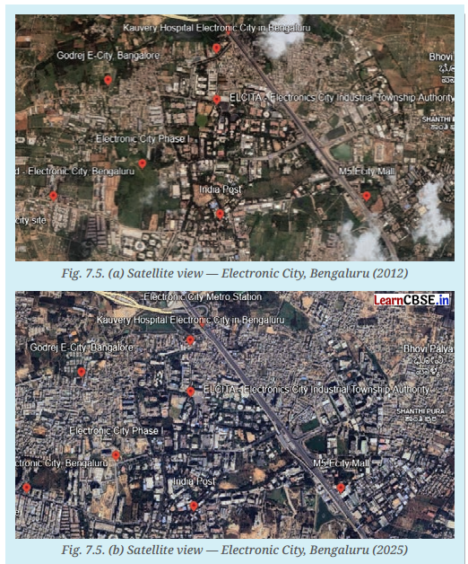
Observe and compare the two satellite images of an area of Bengaluru (Fig. 7.5). They are from 2012 and 2025. respectively. What are your observations? What has changed? Guess what might be the causes for the change. (Pages 194-195)
Answer:
On comparing the two satellite images from 2012 and 2025, several changes can be observed. In the 2012 image, the area appears to have more open land, greenery, water bodies, and fewer buildings. The roads seem less crowded, and there are fewer large constructions.
In the 2025 image, there are many more buildings, apartments, commercial complexes, and roads. Some green areas and possibly water bodies appear reduced. The area looks more densely populated and urbanised. There may also be wider roads, flyovers, and new infrastructure developments.
What Has Changed?
- Increase in residential and commercial buildings
- Reduction in open spaces and greenery
- Expansion of road networks and transport facilities
- Increase in population density
- Possible shrinkage or encroachment of lakes
Possible Causes of Change
The changes may have been caused by rapid urbanisation. Bengaluru has developed as an IT hub, attracting companies, start-ups, and skilled workers from across India. This led to:
- Migration of people for job opportunities
- Demand for housing and office spaces
- Infrastructure development such as roads, metro, and flyovers
- Expansion of industries and business areas
- Thus, economic growth and population increase are likely the main reasons behind the visible transformation of the area between 2012 and 2025.
Question 3.
As a small group project, make a list of adults from different generations in and around your neighbourhood. Draft a questionnaire to enquire into their observations about their own village, town or city and how it has changed over the decades. What, in their view, are the key reasons that towns and cities have changed? If they have grown large, what are the reasons for this? What do they miss about the ‘Old days’ and what do they appreciate about the current time? Report on your project through a presentation to the class. (Page 195)
Answer:
Do it yourself.
Question 4.
Can you name some towns and cities near you? Find out some interesting traditions, cuisines, and customs specific to those areas, and discuss them in class. (Page 203)
Answer:
Do it yourself.
Think About It
Question 1.
The below figures show the satellite view of a village and a city in Haryana, respectively. The Larger blocks of green and brown land on the left in the village show open areas, whereas the grey built-up area on the right shows a complex network of buildings. What can you infer about the population density of the two regions? Why do you think such a difference exists? (Page 193)
Answer:

From the satellite view, we can infer that the village Asadpur Khera, Jhajjar, has low population density, while the Gurugram city in Haryana has high population density. The village shows large green and brown open areas, which indicate agricultural land, fields, and fewer houses spread out over a large area. In contrast, the city shows dense grey built-up areas with many closely packed buildings and roads, suggesting a large number of people living in a smaller space.
This difference exists because cities offer more job opportunities, industries, educational institutions, healthcare facilities, and better infrastructure. As a result, more people migrate to cities in search of employment and better living standards, leading to higher population density. Villages mainly depend on agriculture and have fewer facilities, so fewer people live there compared to cities.
Question 2.
Observe the below pictures. Do you notice the other side of the city? What could be the possible challenges faced by people living in urban slums? (Pages 203 – 204)

Answer:
Yes, the pictures show the other side of the city – urban slums, where many people live in crowded and poor conditions. These areas often lack proper housing and basic facilities.
People living in urban slums face many challenges such as overcrowding, lack of clean drinking water, poor sanitation, and inadequate drainage systems. They may also suffer from frequent diseases due to unhygienic surroundings. Unemployment or low-paying informal jobs, lack of proper schools and healthcare, and insecurity of housing (risk of eviction) are also common problems. These difficulties affect their overall quality of life and well-being.
Class 8 SST Part 2 Chapter 7 Question Answer
Questions and Activities (Pages 212 – 214)
Question 1.
What are some common features of cities?
Answer:
Some common features of cities include a high population density and a large concentration of people living in a limited area. Cities have well- developed infrastructure such as wide roads, flyovers, public transport systems, electricity, water supply, and communication networks. They offer diverse occupations in industries, businesses, offices, educational institutions, and service sectors rather than mainly agriculture. Cities also have government offices, hospitals, schools, markets, shopping centres, and recreational spaces like parks and stadiums. They are governed by elected urban local bodies such as municipal corporations. In addition, cities often serve as centres of economic, cultural, and administrative activities, attracting people from different regions.
Question 2.
Can you think of a city or town near you that has grown in population? What could be the underlying reasons for the urban migration?
Answer:
One city near me that has grown rapidly in population is Gurugram. Over the past two decades, it has transformed from a small town into a major corporate and IT hub with many high-rise buildings, offices, shopping malls, and residential complexes. The underlying reasons for urban migration to Gurugram include the availability of better job opportunities in multinational companies, IT firms, and business process outsourcing (BPO) industries.
Improved infrastructure such as highways, metro connectivity with Delhi, and modern housing has also attracted people. In addition, better educational institutions, healthcare facilities, and higher living standards encourage families to move there. Thus, employment prospects, improved infrastructure, and better services are the main reasons for rapid urban growth and migration.
Question 3.
With reference to the epigraph at the beginning of the chapter, who are the participants in the making of the city and what could be their contribution?
Answer:
The epigraph given at the beginning of the chapter:
Cities have the capability of providing something for everybody only because, and only when, they are created by everybody. – Jane Jacobs.
American Urbanist. The epigraph by Jane Jacobs suggests that cities succeed when they are shaped by the collective efforts of all sections of society. The participants in the making of a city include government authorities and urban planners, who design policies, infrastructure, housing, transport systems, and public services. Architects and engineers contribute by constructing safe buildings, roads, bridges, and utilities. Business owners and industrialists generate employment and economic growth. Workers, including skilled professionals, factory workers, street vendors, domestic helpers, and construction labourers, keep the city functioning daily.
Residents and community groups participate through civic engagement, maintaining neighbourhoods, conserving resources, and raising concerns about local issues.
Question 4.
In what ways can urbanisation affect rural areas? Do cities also depend on rural areas? If yes, how? In what ways can rural and urban areas help each other develop?
Answer:
Urbanisation can affect rural areas in several ways. When cities expand and offer more jobs, many people migrate from villages to towns and cities in search of better employment, education, and healthcare. This can reduce the rural workforce, especially in agriculture. At the same time. urban growth increases the demand for agricultural produce, raw materials, water, and labour from rural areas. Land near cities may also be converted from farmland into housing or industrial use, changing rural landscapes and livelihoods.
Yes, cities depend heavily on rural areas. Urban populations rely on villages for food grains, vegetables, milk, fruits, and other agricultural products. Rural areas also supply raw materials for industries and provide labour for construction, factories, and domestic services. In addition, cities depend on rural regions for water resources and
sometimes electricity generated from dams and power plants located outside urban areas.
Rural and urban areas can help each other develop through mutual cooperation. Cities can provide markets for rural products and better prices for farmers. Access to technology, healthcare, and education. Improved transport and digital connectivity can link farmers directly to urban consumers.
Rural areas, in turn, support cities by ensuring food security, supplying labour, and maintaining ecological balance. Balanced and sustainable development requires strong connections and cooperation between rural and urban regions.
Question 5.
What is urban planning? What are the risks of ignoring sustainable urban planning as cities expand into villages and forest areas?
Answer:
Urban planning is the process of designing and organising the physical layout and development of cities. It involves planning housing and roads. transport systems, water supply, drainage, waste management, public facilities (such as schools and hospitals), green spaces, and commercial areas in a systematic and sustainable way. The aim of urban planning is to improve the quality of life of residents while ensuring balanced economic growth and environmental protection.
Ignoring sustainable urban planning as cities expand into villages and forest areas can create serious risks. Unplanned expansion may lead to the destruction of forests, loss of biodiversity. and reduction of agricultural land. It can cause water shortages, flooding during monsoons due to poor drainage, and increased air pollution.
Encroachment on natural water bodies may worsen water scarcity and urban heat. Rapid, unplanned growth can also result in traffic congestion, overcrowded housing. Growth of slums and strain on infrastructure like electricity and sanitation systems. In the long term, such neglect can reduce the quality of life, increase health problems, and make cities environmentally and socially unsustainable.
Question 6.
Observe your own neighbourhood. What signs of good or poor planning do you notice? How do they affect daily life for you and others?
Answer:
In my neighbourhood. 1 notice both signs of good and poor planning. On the positive side, there are paved roads, streetlights, nearby schools, grocery shops, and a park where children and elderly people can spend time. Public transport such as buses or metro connectivity makes commuting easier. Proper drainage in some areas prevents waterlogging during light rains. These features make daily life convenient and safe for residents.
However, there are also signs of poor planning. In some lanes, traffic congestion is common due to narrow roads and illegal parking. During heavy rains, water sometimes collects because of blocked drains. There are fewer green spaces than before, and increasing construction has reduced open areas. Waste is not always segregated properly.
which affects cleanliness.
These problems lead to pollution, longer travel time, inconvenience, and health concerns. Overall, good planning improves comfort and safety, while poor planning creates stress and reduces the quality of daily life for everyone.
Question 7.
Imagine you are an urban planner. What are the things you would consider to plan a city? Do groups like children, the elderly, and people with disabilities get easy access to parks, toilets, and public transport? What changes would you introduce to make it more inclusive?
Answer:
If I were an urban planner, I would plan the city as a balanced and sustainable space that meets the needs of all people. I would consider population size, housing requirements, road networks, public transport, water supply, drainage, waste management, green spaces, schools, hospitals, markets, and safety measures. I would ensure
proper zoning so that residential, commercial, and recreational areas are well connected but not overcrowded.
Environmental protection, rainwater harvesting, energy efficiency, and climate resilience would also be important priorities. In many cities, groups like children, the elderly, and people with disabilities do not always get easy
access to parks, clean public toilets, or convenient public transport.
Footpaths may be uneven, buses may not have ramps. And public spaces may lack proper seating or lighting. This makes daily movement difficult and sometimes unsafe.
To make the city more inclusive, I would introduce barrier-free footpaths, ramps, lifts, tactile paving for the visually impaired, and low-floor buses. Parks would include safe play areas for children and walking tracks with benches for senior citizens.
Public toilets would be clean, well-maintained, and accessible to persons with disabilities. I would also promote pedestrian-friendly streets, cycling tracks, and well-lit public areas to ensure safety for all. An inclusive city ensures that everyone-regardless of age or ability—can participate comfortably in urban life.
Question 8.
Suppose your town, village, or city has 100 people. Draw a rough map of the place on a graph paper. Imagine each square on the paper represents a specific area of the place, like residential neighbourhoods, parks, schools, factories, post offices and so on. Now, distribute the 100 people throughout the area. You can decide where the people will live, whether they all live in the residential areas, or some live in the commercial or industrial areas. Write this number in each of the boxes. In your depiction of the map, which areas are heavily populated and which are not? What were the reasons behind your choices of allocation of people?
Answer:

I imagined my town as a small planned city divided into different areas such as residential neighbourhoods, markets, schools, factories, parks, and public service areas. Since there are 100 people in total, I distributed them according to how people usually settle in a town.
I allocated 70 people to residential areas because most people live in houses or apartments. I placed 10 people in the commercial area (market and shops), as shopkeepers and workers may stay near their workplaces. I allocated 8 people in the industrial area for factory workers. Around 5 people were placed near schools and public institutions
(teachers and stalls). I kept 3 people near transport hubs like bus stops or railway areas. Parks and open spaces were given 2 people, as very few people live directly inside such areas. The remaining 2 people were placed near government offices and service areas such as the post office.
In my map, the residential areas are the most heavily populated because most people prefer living in housing colonies. Commercial and industrial areas are moderately populated since only workers and some business owners may live there. Parks and public utility spaces are the least populated because they are mainly for public use and not for residence.
I made these choices because, in real towns and cities, housing areas usually contain the majority of the population, while workplaces and recreational spaces have fewer permanent residents. This distribution shows how population density differs across different parts of a settlement.
Question 9.
Observe the satellite view of Mumbai and Gangtok, respectively. Find out their population density and likely reasons for the difference

Answer:
When we look at population density, Mumbai is one of the most crowded cities in India. In the Mumbai area, tens of thousands of people live in every square kilometre – for example, the Mumbai Suburban district has around 20,980 people per sq km, and the city area itself around 19,652 people per sq km, according to census estimates. This extremely high density is due to its role as India’s financial capital, with many job opportunities in business,
services, entertainment, and industries that attract people from all over the country.
In contrast, Gangtok has a much lower population density. Based on older census and estimates, Gangtok’s density is significantly lower than Mumbai’s. Far fewer people live in each square kilometre in Gangtok because the city is smaller, in hilly terrain, and its economy relies more on tourism, government services, and local trade rather
than large-scale industries.
The likely reasons for the difference are:
Economic Opportunities: Mumbai has many industries, offices, banks, and businesses that offer jobs, so more people move there.
Geography: Gangtok is in the hills with limited space to expand, whereas Mumbai’s flat coastal location allows large-scale settlement and infrastructure development.
Migration: Cities like Mumbai attract internal migrants from villages and smaller towns, increasing density. Gangtok grows more slowly because it attracts fewer migrants.
Question 10.
Find out how the city of Beijing, China, tackled the problem of air pollution. Prepare a report outlining measures that can be taken in India to mitigate air pollution in cities.
Answer:
Beijing was once known as one of the world’s most smog-ridden cities, but over the past decade it has significantly improved its air quality through strong and sustained efforts by the government and local authorities. Beijing launched a large-scale clean air campaign beginning in 2013 with strict pollution control targets and long-term planning.
It reduced the burning of coal by replacing coal-based energy with cleaner fuels, lowering coal consumption from
millions of tonnes a year to less than 1% of total energy use by 2024. Beijing also closed or relocated over 3,000 heavy industries that were major sources of harmful emissions, freeing space for parks and other clean uses. The city tightly regulated vehicle emissions by phasing out old, high-pollution vehicles, enforcing ultra-strict emission standards, and limiting the number of new cars through license-plate controls. It invested heavily in public
transport, including expanding metro networks and promoting electric buses, which encouraged people to use mass transit instead of private cars. Real-time air quality monitoring and regional cooperation with surrounding provinces helped control pollution beyond city limits. As a result, Beijing’s average level of fine particulate matter (PM 2.5) dropped significantly, good air quality days increased, and days with severe smog almost disappeared.
Measures India can take to mitigate air pollution in cities are:
India faces serious air pollution challenges in cities like Delhi. where smog often reaches hazardous levels and threatens public health.
Based on lessons from Beijing and India’s own clean-air efforts, the following steps can help:
1. Phase out coal and dirty fuels: Reduce reliance on coal for heating and industry by switching to cleaner
energy sources such as natural gas, solar, and wind.
2. Control vehicle emissions: Introduce stricter emission standards for vehicles, phase out old, high-pollution vehicles, and promote electric vehicles with incentives.
3. Limit traffic pollution: Increase investments in public transport such as metro trains, buses, cycle tracks, and pedestrian paths to reduce private vehicle use.
4. Industrial regulation: Move highly polluting industries away from dense urban areas and enforce clean technology standards to reduce smoke and particulate emissions.
5. Green spaces: Plant trees and create parks that act as lungs of the city and help absorb pollutants.
6. Monitoring and awareness: Set up more air quality monitoring stations and share data publicly so citizens know pollution levels and can take precautions.
7. Regional cooperation: Work with nearby towns and states to manage pollution sources together, especially for problems like stubble burning in rural areas that affect city air.
8. Dust and construction controls: Regulate dust from roads and construction sites through water spraying, proper planning, and better enforcement. By combining strong policies, clean energy transitions, better transport systems, and community cooperation, Indian cities can reduce pollution and improve public health just as Beijing managed to improve its air over time.
Question 11.
Talk to a family or community member who has moved from a village to a city. Ask them the reason for the same and their experience, challenges, and opportunities. How does city life compare to rural life?
Answer:
Do it yourself.
Question 12.
Learn about urban planning in other cities around the world. In what ways can some of those aspects be adapted for a city near you?
Answer:
Urban planning in several cities around the world offers useful lessons. For example, Singapore is known for its long-term planning, mixed-use development, efficient public transport, and large number of green spaces. The city integrates housing, offices, parks. and public services within close distance and promotes walkability. Curitiba
is famous for its Bus Rapid Transit (BRT) system, which provides fast and affordable public transport.
Copenhagen has excellent cycling infrastructure, encouraging people to use bicycles instead of cars, which reduces pollution. Tokyo is known for its punctual and highly efficient metro system that connects the entire city seamlessly.
These aspects can be adapted to a city near me, such as Delhi. Delhi can further expand safe cycling tracks like Copenhagen, improve bus-based rapid transport systems like Curitiba, and increase green buildings and rooftop gardens like Singapore. Mixed-use neighbourhood planning can reduce long travel distances between homes and workplaces. Strengthening metro connectivity and last-mile transport, similar to Tokyo, can reduce traffic congestion.
By adapting global best practices-such as efficient public transport, pedestrian-friendly roads, green infrastructure, and long-term planning -Indian cities can become cleaner, more inclusive, and more sustainable while meeting the needs of growing populations.
Question 13.
Explore and suggest action points with respect to urban planning in cities to mitigate the challenges below and write a report. Two have been completed for you. Waste Management: Conducting a ‘Segregate at Source’ awareness drive in residential areas with demos on dry/ wet waste disposal and composting. Traffic congestion: carpooling, high taxes on vehicle purchase, etc.
Inadequate safety of residents
Poor mobility within the city
Expansion of slums
Heat waves during summers
Answer:
Report on action points for better urban planning:
Urban areas today face multiple challenges due to rapid population growth and unplanned expansion. While steps like waste segregation and measures to reduce traffic congestion are important, cities must address several other concerns through proper planning and community participation.
The following action points are suggested:
(i) Inadequate Safety of Residents: To improve safìty in cities:
- Install proper Street lighting in all areas, especially isolated lanes.
- Increase CCTV surveillance in public spaces.
- Ensure regular police patrolling and establish easily accessible police booths.
- Design safer public transport with panic buttons and helplines.
- Promote community watch groups and Residents Welfare Associations (RWAs).
- Create well-lit pedestrian pathways and safe crossings.
- These measures can reduce crime and make residents feel more secure.
(ii) Poor Mobility within the City: To improve mobility:
- Expand and modernise public transport such as buses and metro systems.
- Introduce dedicated cycling tracks and pedestrian-friendly pathways.
- Improve last-mile connectivity through c-rickshaws and feeder buses.
- Promote smart traffic management systems using digital monitoring.
- Develop mixed-use neighbourhoods to reduce long- distance travel.
- Better mobility reduces pollution, saves time, and improves quality of life.
(iii) Expansion of Slums: To address slum expansion:
- Provide affordable housing schemes for economically weaker sections.
- Upgrade slum areas with proper water supply, sanitation, and electricity.
- Promote skill development and employment opportunities.
- Prevent illegal encroachments through planned housing development.
- Encourage public-private partnerships for low-cost housing projects.
- Improving housing conditions ensures dignity and better living standards for all citizens.
(iv) Heat Waves During Summers To reduce the impact of heat waves:
- Increase tree plantation drives and protect existing green spaces.
- Promote rooftop gardens and vertical greenery.
- Use heat-resistant and reflective materials in construction.
- Develop water bodies and restore lakes to cool the environment.
- Create shaded bus stops and public spaces.
- Encourage rainwater harvesting and sustainable building designs.
- These steps can reduce the urban heat island effect and make cities more climate-resilient.
Conclusion: Urban planning must focus on safety, mobility, housing, and climate resilience. Sustainable and inclusive planning, combined with citizen participation, can help cities grow while maintaining environmental balance and improving residents’ well-being.
Question 14.
Find out about a slum rehabilitation program where people moved from slums to proper housing in your city. What do you think its possible benefits could be for the communities there?
Answer:
Report on a Slum Rehabilitation Programme: One important slum rehabilitation initiative is the Slum Rehabilitation Authority (SRA) project in Mumbai. The SRA was set up by the Government of Maharashtra to provide free housing to eligible slum dwellers. Under this programme, slum residents are shifted from temporary huts made of tin and plastic sheets into permanent multi-storey apartment buildings with proper walls, roofs, electricity, water supply, sanitation, and sewage systems. Builders are allowed to develop part of the land commercially in return for constructing free housing for slum residents.
Possible Benefits for the Community
- Improved Living Conditions: Families get safe and permanent houses instead of overcrowded and
unhygienic shelters. - Better Sanitation and Health: Access to clean water, toilets, drainage systems, and waste management reduces the spread of diseases.
- Safety and Security: Strong buildings protect residents from floods, fires, and extreme weather conditions.
- Access to Services: Proper housing makes it easier to access schools, hospitals, transport, and other civic facilities.
- Dignity and Social Inclusion: Living in formal housing improves self-respect and social status.
- Environmental Improvement: Clearing slums can reduce pollution and improve City planning when done responsibly.
However, for rehabilitation to succeed, authorities must ensure good maintenance, livelihood opportunities, and community participation. Overall, slum rehabilitation programmes can significantly improve quality of life when planned carefully and implemented fairly.
The post India’s Urban Landscape Class 8 Question Answer SST Part 2 Chapter 7 appeared first on Learn CBSE.
from Learn CBSE https://ift.tt/ocPf4Uw
via IFTTT

No comments:
Post a Comment